10 Best Hikes Near Lauterbrunnen (Easy To Challenging + Map) | Anywhere We Roam
The Lauterbrunnen Valley is the Switzerland of postcards and travel brochures. The best way to see it is on trails that wind above and below its vertical rocky walls. Here’s our guide to the best hikes near Lauterbrunnen.
By: Mark Barnes |
Published: 5 Apr 2024
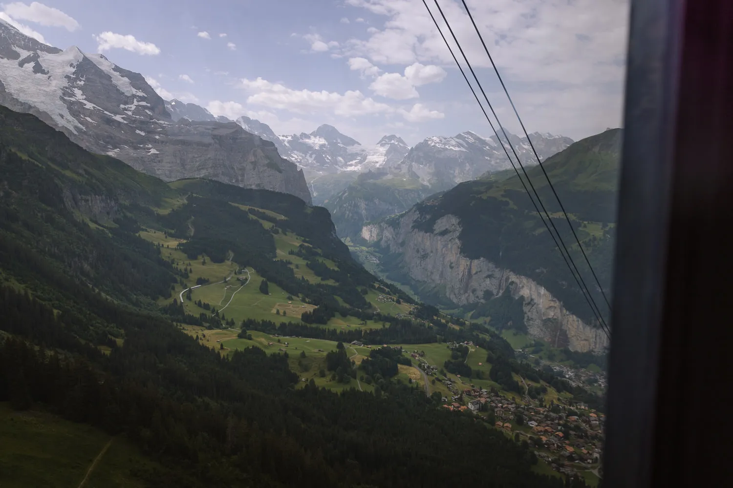
The Lauterbrunnen Valley is the most dramatic valley in Europe. Its 400m high vertical cliffs are cut by up to 72 waterfalls plunging towards the flat green valley floor. Above the rocky walls rustic wooden chalets and villages are backed by 4,000m high snow-capped mountains.
It is the Switzerland you see in postcards and travel brochures.
The central hub of the valley is the town of Lauterbrunnen, from where a myriad of cable cars and trains connect a maze of trails.
There is a suitable hike for all levels of fitness. Some trails allow for easy walks along the valley floor. Others are more challenging, heading above the cliff walls to explore the high mountain peaks.
These are our top hikes near Lauterbrunnen organised via easy, medium and challenging treks. We have included maps, route instructions, and tips for getting that perfect photo.


WHERE IS LAUTERBRUNNEN?
The Lauterbrunnen Valley is just south of Interlaken in a mountainous region of Switzerland called the Bernese Oberland. Five miles long and rarely more than half a mile wide, the U-shaped valley has a flat base surrounded by vertical cliffs up to 400m high.
The town of Lauterbrunnen sits at the entrance to the valley and is regularly served by trains from Interlaken. Cable cars and funiculars head up the valley walls to towns that sit atop the cliffs providing easy access to some amazing hikes.
This post covers all the best walks near Lauterbrunnen. However, there are lots of other great hikes near Interlaken and across the Bernese Oberland region. In particular, don’t miss the Oeschinen Lake Panoramaweg.

MAP | BEST HIKES NEAR LAUTERBRUNNEN
The below map contains each of the routes for our favourite hikes near Latuerbrunnen. Each hike is colour-coded. All the details are included in the descriptions further down in this guide.
How to use this map / Click on the top left of the map to display the list of locations, then click on the locations to display further information. Click on the top right corner of the map to open a larger version in a new tab or the star to save to your Google Maps.
EASY HIKES NEAR LAUTERBRUNNEN
Our 6 easy hikes near Lauterbrunnen are under 7 kilometres and can be done in less than 2 hours and 15 minutes. Most are flat or downhill, and those that are uphill have no more than 150 metres ascent.
MODERATE HIKES NEAR LAUTERBRUNNEN
Our 2 moderate walks are 6-7 kilometres long and require a bit more ascent or descent or walking through snow. They take between 2 hours and 4 hours to complete and are more physically demanding.
CHALLENGING HIKES NEAR LAUTERBRUNNEN
Our 2 challenging hikes are both over 10 kilometres taking about 5 hours to complete. The Männlichen to Alpiglen hike is almost in the moderate section, so well worth a go if you want a challenge, but not too much of one.

1 – STAUBBACH FALLS
The Staubbach Falls provides one of the most iconic photos in the Swiss Alps. This magical wisp of water plunges 297 metres over the vertical valley walls, making it the third-highest waterfall in the Lauterbrunnen Valley.
The short hike begins at Lauterbrunnen Train Station and heads to the base of the falls. From here you get a true appreciation of the sheer size of the cliff face as the water drops towards you.
The hike is a simple 1km each way along the road and almost entirely flat. Almost all the way is paved, however the final 200m is along a dirt track allowing you to get almost directly under the spray.
Tip | Easy hike for the day you arrive in the valley. Most of it can be done with a stroller.
ROUTE DETAILS // STAUBBACH FALLS
Distance – 2 kilometres (1.25 miles) | Time – 30 minutes | Elevation – 50 meters (165 feet) ascent and descent | Difficulty – Easy | Start & End – Lauterbunnen Train Station | Map – Orange & Red trail

2 – JUNGFRAU EIGER WALK
This is a great little trail to do on the way down from the Jungfraujoch. It only takes 30 minutes and it’s all downhill.
The hike begins at Eigergletscher Station from where you can almost touch the tongues of snow and ice coming down the rocky faces of Mönch and Jungfrau.
The hike descends passing a charming wooden mountain hut that peers over the Lauterbrunnen Valley. Take a shot at the artificial lake of Fallbodensee, before making your way to Kleine Scheidegg.
At Kleine Scheidegg you can get the train back to Lauterbrunnen.
Tip | Keep an eye out for photo opportunities of the Jungfraujoch train as you walk down.
ROUTE DETAILS // JUNGFRAU EIGER
Distance – 2.5 kilometres (1.5 miles) | Time – 30 minutes | Elevation – 260 meters (850 feet) descent | Difficulty – Easy | Start – Eigergletscher | End – Kleine Scheidegg | Map – Green trail


3 – TRÜMMELBACH FALLS
The Trümmelbach Falls (April to November 9 am to 5 pm), are Europe’s largest subterranean waterfalls. Carved by glacial meltwater from the Mönch, Eiger, & Jungfrau mountains, up to 20,000 litres per second crash through the tunnels.
Deep inside the valley walls the 10 roaring falls have been accessible by a series of lifts, tunnels, and platforms. It takes about 1 hour to hike the metal walkways and explore the falls.
There’s a fee to enter and often a queue waiting for the lift. But the sheer power of the falls is a sight to see.
The easiest access point is Trümmelbach bus stop, 7-minute bus ride from Lauterbrunnen (every half hour during the day). From the bus station it is just 250 metres to the entrance and lift.
Tip | Bring a raincoat and shoes with good grip.
ROUTE DETAILS // TRÜMMELBACH FALLS
Distance – 1.5 kilometres (0.9 miles) | Time – 1 hour | Elevation – 140 metres (460 feet) descent | Difficulty – Easy | Start & End – Trümmelbach Bus Station | Map – Purple trail


4 – GRÜTSCHALP TO MÜRREN
This easy trail ascends the balcony between Grütschalp and Mürren.
The path goes in and out of trees, revealing glimpses of the stunning Lauterbrunnen valley.
There are grand views across to the town of Wengen and up to the mighty Eiger, Mönch and Jungfrau mountains.
The walk ends in Mürren where car-free lanes surround cute wooden chalets.
Tip | This is an easy and pleasant walk, but you can also get many of the same views on the train that runs between Grütschalp and Mürren. So, you could save your energy for another hike.
ROUTE DETAILS // GRÜTSCHALP TO MÜRREN
Distance – 4.5 kilometres (2.8 miles) | Time – 1 hour and 30 minutes | Elevation – 150 metres (490 feet) ascent | Difficulty – Easy | Start – Grütschalp | End – Mürren | Map – Light grey trail


5 – MÄNNLICHEN PANORAMA TRAIL
A wonderful easy hike near Lauterbrunnen, the Männlichen Panorama Trail has truly magnificent views.
It starts at the Männlichen Cable Car Station, which has a perfect view of the Lauterbrunnen Valley and Staubbach Waterfall.
The trail heads towards Kleine Scheidegg with the trio of snow-capped giants – Eiger, Mönch, and Jungfrau in front of you and the town of Grindelwald on your left.
The path is well-signed and very easy to follow. As you make progress, the 1,800m high daunting north face of the Eiger becomes more and more imposing.
Just before reaching Kleine Scheidegg stop at Restaurant Grindelwaldblick for a break. Head up to its watchtower for one of the most scenic views in Switzerland.
Tip | From Männlichen cable car an optional detour takes you to the Männlichen summit. The views from here are even better. It is a little higher, so it has a better angle looking down the Lauterbrunnen Valley. Add 500 metres each way and 120 metres of ascent and descent to include this detour.
ROUTE DETAILS // MÄNNLICHEN PANORAMA TRAIL
Distance – 4.6 kilometres (2.85 miles) | Time – 1 hour 30 minutes | Elevation – 160 metres (525 feet) descent | Difficulty – Easy | Start – Männlichen | End – Kleine Scheidegg | Map – Blue trail


6 – LAUTERBRUNNEN VALLEY WALK
The Lauterbrunnen Valley is possibly the most beautiful valley in Europe. Its sheer-sided walls are cut by 72 waterfalls, some of which drop up to 400 metres.
This easy hike begins at Stechelberg Bus Station, and follows the valley floor between Stechelberg and Lauterbrunnen. There is almost no ascent or descent making it a very pleasant stroll in stunning surroundings.
The hike passes very close to the two falls mentioned above – Trümmelbach & Staubbach Falls. A great half day out is to hike this Lauterbrunnen Valley Walk, stopping off at the two falls on route.
ROUTE DETAILS // LAUTERBRUNNEN VALLEY
Distance – 6.8 kilometres (4.25 miles) | Time – 2 hours | Elevation – 120 metres (395 feet) descent | Difficulty – Easy | Start – Stechelberg | End – Lauterbrunnen | Map – Orange trail

7 – NORTH FACE TRAIL
This excellent hike near Lauterbrunnen can be completed in either direction.
Going downhill from Allmendhubel to Mürren we would rank it as easy. Going uphill from Mürren to Allmendhubel we’d call it moderate.
Either way, the trail is well-signed. Simply follow the blue ‘North Face-Trail’ markers at each junction.
The trail is a great exploration of grassy meadows dotted with cute wooden chalets. Cows, pigs, goats, and horses dot the landscape as the path meanders past rustic barns and working farms.
There are grand views up to the Schilthorn and across the upper end of the Lauterbrunnen Valley.
Allmendhubel has a restaurant and play area. Mürren, perched on the edge of a vertical cliff is one of the more enchanting villages in Switzerland.
ROUTE DETAILS // NORTH FACE
Distance – 6.5 kilometres (4 miles) | Time – 2 hour 30 minutes | Elevation – 390 metres (1,280 feet) ascent and 60 metres (200 feet) descent | Difficulty – Easy to Moderate | Start – Allmendhubel | End – Mürren | Map – Brown trail


8 – MÖNCHSJOCHHÜTTE
One of the best things to do at the Jungfraujoch is to hike to Mönchsjoch Hut. The highest altitude serviced hut in Switzerland, it stands at a staggering 3,658 metres.
All year round, snow and ice surround the rocky pinnacle on which it stands.
Fortunately, it’s only 1.5 miles from the Jungfraujoch Observation Deck at 3,463m. However, hiking through snow at high altitudes often takes longer than you think. We’d recommend allowing 2 hours for the round trip.
Warm up with a coffee at Mönchsjoch Hut.


A few suggestions for this hike:
- The high-altitude trail can often be closed so check before you leave.
- It’s very cold at the summit of this hike, (zero degrees even in peak summer) so bring warm clothes and waterproof boots.
- It can also be very sunny and the reflection off the snow can be blinding so don’t forget your sunglasses and sunblock.
- No mountaineering skills are required, it’s just a simple walk-through snow.
Our Recommendation | This is a great hike to do if you already plan on taking the train up the Jungfraujoch. However, the train is very expensive, and it’s not worth paying for it, just to do the hike.
ROUTE DETAILS // MÖNCHSJOCHHÜTTE
Distance – 4 kilometres (2.5 miles) | Time – 2 hours | Elevation – 210 metres (690 feet) ascent and descent | Difficulty – Moderate | Start & End – Jungfraujoch | Map – Black trail

9 – MÄNNLICHEN TO ALPIGLEN HIKE
This wonderful hike combines three shorter trails and collects many of the best views near Lauterbrunnen.
It begins at the Männlichen Cable Car Station. From here, you can take an optional detour to the top of Männlichen for excellent views of the Lauterbrunnen Valley.
Next, the trail follows the Männlichen Panoramaweg. This path traverses under the ridgeline towards Kleine Scheidegg. Glorious views of the three mighty peaks of Eiger, Mönch, and Jungfrau tower in front of you.
At Kleine Scheidegg the path follows the Jungfrau Walk, climbing up to Eigergletscher.
From here it follows the Eiger Trail, which traverses under the mighty north face of the Eiger.


It ends at Alpiglen Train Station where you can get the train up to Kleien Shceidegg and back down into Lauterbrunnen.
There is nothing technically difficult on this walk and all the trails are well signed. Restaurant Grindelwaldblick is our choice for lunch. It has a little watchtower to catch the best of the views.
ROUTE DETAILS // MÄNNLICHEN TO ALPIGLEN
Distance – 13.25 km (8.25 miles) | Time – 5 hours | Elevation – 340 metres (1,115 feet) ascent and 945 metres (3,100 feet) descent | Difficulty – Moderate | Start – Männlichen | End – Alpiglen | Map – Blue, green, and light green trails


10 – SCHILTHORN TO MÜRREN HIKE
This hike starts from Piz Gloria Cable Car Station at the top of the Schilthorn. The rotating restaurant with 360-degree views featured in the James Bond film, On Her Majesty’s Secret Service.
The first hour of this hike is a lovely walk along a wild rocky ridge.
Although it has steep drops on either side, the path is wide and not too exposed. There are a couple of metal ladders and handrails to assist and often large piles of rocks to protect you on one side.
At the end of the ridge, the path drops steeply down the flanks of the mountain. This is a long 1,000-metre descent. The rocky trail gradually turns to grassy meadows dotted with alpine flowers. The mountains of the Bernese Oberland spread out in front.
The trail can be tricky to spot in places so make sure you keep referring to the map.
About 90 minutes after leaving the ridge, the trail reaches Rotstochhütte, a perfect spot to stop for lunch.
From here it’s just over 2 hours and 400 additional metres of descent back to Mürren. The last part of the hike is on part of the North Face Trail.
It’s a challenging hike that takes about 5 hours walking, but you’ll want to leave at least 6 hours for lunch and photos.
ROUTE DETAILS // SCHILTHORN TO MÜRREN
Distance – 11 kilometres (6.8 miles) | Time – 5 hours | Elevation – 1,400 metres (4,600 feet) descent | Difficulty – Moderate to Challenging | Start – Schilthorn | End – Mürren | Map – Dark grey trail


HIKES NOT TO MISS NEAR LAUTERBRUNNEN
Most people only spend three or four days in the Lauterbrunnen Valley and cannot hope to complete all the hikes in that time. So, here are our top Lauterbrunnen hikes which we suggest you don’t miss.
- Best Easy Hike – Lauterbrunnen Valley (Staubbach & Trümmelbach)
- Best Moderate Hike – Mönchsjochhütte
- Best Challenging Hike – Männlichen to Alpiglen
BEST TIME TO HIKE NEAR LAUTERBRUNNEN
September is the best time to hike near Lauterbrunnen.
The summer hiking season runs from mid-June to mid-October, but snow can still cover the higher trail early in the season.
The trails are at their most busy during the summer holidays from mid-July to the end of August. It’s a beautiful time to visit when the meadows are lush and the alpine flowers blooming. But you’ll rarely have a trail to yourself.

THANKS FOR VISITING // WHERE NEXT?
A BIG THANK YOU
We’ve been providing free travel content on Anywhere We Roam since 2017. If you appreciate what we do, here are some ways you can support us.
Thank you!
Paul & Mark
FOLLOW US ON INSTAGRAM
USE OUR RESOURCES PAGE

