15 Amazing Places To Visit In The Iceland Highlands (+ Map)
With the ring road getting busier every year, take your sense of adventure off the beaten path and into the dramatic natural scenery of Iceland’s Highlands. Here’s where to go and how to get there.
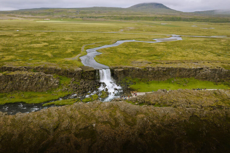
The highlands of Iceland are the country at its most remote and beautiful and many of the best places to visit in Iceland can be found here..
Majestic volcanos that scar the region do more than just cause travel disruptions. They create a weird landscape, unlike anywhere else on earth. Bubbling mud pots, rivers winding through colourful mountains, huge glaciers and barren landscapes cloaked in the moody mystery of steaming sulphur vents.
In the emptiness of the highlands, the crowds following a Ring Road itinerary are a distant memory and a real wilderness adventure begins. The vistas are grand, the roads rough, and the facilities minimal.
Getting there is exciting too. Venturing onto the highland mountain roads can involve fording rivers, bumping over boulders, and driving through sand. To drive yourself you’ll need a 4×4 SUV and an affinity for bumpy roads or you can join one of the increasing number of tours that head into this remarkable wilderness.
This guide covers an overview of Iceland’s highlands, all the best places to see, self-drive instructions and some highly recommended tours.
Booking your trip via the links on this page (or on our book page) will earn us a small commission, at no extra cost to you. Thanks for your support – Paul & Mark.

WHAT ARE THE ICELAND HIGHLANDS?
The Iceland Highlands are vast zones of uninhabited volcanic desert which has formed above the mid-Atlantic rift (a gap between two tectonic plates). Destroyed by volcanic activity then re-formed through the forces of nature; the Iceland Highlands are a continually changing environment.
Although it’s possible to spend hours driving off the beaten path through nothing but barren black and grey rocks, find the right spot and the natural beauty of this part of Iceland is mesmerising.
WHERE ARE THE HIGHLANDS?
The Iceland Highlands are a huge landmass, stretching across the centre of the country and covering over 40,000 square kilometres (25,000 square miles).
The popular Ring Road (Route 1) circles the edge of Iceland, not because there’s nothing to see in the middle, but because the highlands are inaccessible for most of the year.


HOW TO GET TO THE HIGHLANDS?
Accessing the highlands requires travelling on the F-roads (or mountain roads). These are gravel tracks that are not regularly maintained and are only open during the summer months. They often involve driving across rivers and as such, only 4×4 vehicles are permitted on the F-Roads.
If you are thinking about hiring a 4×4 read our complete guide about driving on the F-Roads.
Alternatively, if you want to skip the self-drive excursion, there are plenty of organised tours and a highland bus that visits most of the places in our guide.
Details on how to incorporate the highlands into your trip are covered in our Iceland itineraries guide as well as on our tips for planning a trip to Iceland post.
MAP – ICELAND HIGHLANDS
We have marked all the top highland destinations on the below map. Travelling to the highlands generally involves heading in for the day then back out a gain. So to visit these places, you ideally want to be based close to the Ring Road near the F-Road junction for the destination you are visiting.
How to use this map / Click on the top left of the map to display the list of locations, then click on the locations to display further information. Click on the top right corner of the map to open a larger version in a new tab or the star to save to your Google Maps.
IS VISITING THE ICELAND HIGHLANDS WORTH IT?
Yes, there are three great reasons to visit the Highlands of Iceland.
Firstly, it has some of the finest natural scenery in Iceland. Expect to see beautiful rainbow-coloured mountains, canyons cut deep into barren landscapes, waterfalls cascading over multi-layered gorges, steam rising from cracks in the earth’s surface, hot natural pools, and bubbling mud pots. There are volcanos and glaciers, sandy deserts, and mazy lakes.
Secondly, most tourists stay in the southwest of Iceland or circle the Ring Road making these destinations busy. Head into the highlands and you’ll quickly get away from the crowds and enjoy amazing natural scenery, often having it all to yourself.
Finally, getting there is all part of the adventure. While there are an increasing number of Iceland Highland day tours, heading out under your own steam is a thoroughly rewarding experience.

BEST PLACES TO VISIT IN THE ICELAND HIGHLANDS
1 – KERLINGARFJÖLL
Kerlingarfjöll is a small but stunning mountain range right in the centre of Iceland. Its snow-capped summits are wedged between two mighty glaciers. But the real highlight is hidden in one of its valleys.
Lurking under the snowy peaks is the geothermal area of Hveradalir. Gurgling rivers wind around red & brown rhyolite mountains; bubbling mud pots erupt into the air; steaming vents shroud the valley in mystery. It’s a volcanic wonderland of breath-taking natural scenery, easily explored on the hiking trails that criss-cross the area.
Kerlingarfjöll is accessed on the 35 and F347 from either north or south. They are two of the easiest mountain roads to navigate. Mostly gravel tracks, they are rocky in a couple of places but there are no river crossings. All the information, including the details for catching the bus are on our Kerlingarfjöll Guide.


2 – HVERAVELLIR
The geothermal area of Hveravellir (hot springs fields) is 1 hour north of Kerlingarfjöll. A series of paths through steaming lava fields and bubbling mud pots deliver you to one of the most remote natural springs in Iceland.
A dam has been built in the flow of the stream creating a small pool that fluctuates between 20 and 40°C (68-140°F). It’s a lovely, natural thermal pool. Find the right temperature spot, then soak while staring out at the magnificent vistas in one of the most scenic hot springs in Iceland.
There are no changing facilities, but there is a wooden bench and some hooks to store your gear. Alternatively, there are toilets a couple of hundred meters away.
HOW TO GET TO HVERAVELLIR
Route – 1 hour north of Kerlingarfjöll on the 35 Kjölur Road | Difficulty – Easy f-roads; no river crossings | Vehicle – Any sized 4×4 | Time – 2 hours, 30 minutes (from Gulfoss); 1 hours, 30 minutes from Rte 1 north
MORE DETAILS


3 – ASKJA
Askja is a series of interlinking calderas and craters deep in Iceland’s highlands. The largest is the country’s finest example of a subsidence caldera. Over 30 square miles in size it was formed when a massive magma chamber collapsed during an eruption. Today a lake of brilliant sapphire blue water forms in its base.
Tucked into one edge of this massive caldera is the smaller Viti Crater. Created by a more recent explosion, the burnt orange and yellow crater is filled with a milky white geothermal pool at a pleasant 25°C to 30°C (77°F to 86°F).
Getting to Askja involves travelling on one of the more challenging roads in Iceland. It’s over a 3-hour drive through the most desolate and barren scenery in the highlands. The journey involves crossing two significant rivers, driving over lava fields and crossing a large sandy patch.
All the details are in our guide to Askja.


4 – LANDMANNALAUGAR
Landmannalaugar is situated within a massive caldera in the Fjallabak National Reserve on the southwest edge of Iceland’s highlands. It is the most varied of the highland landscapes with colourful rhyolite mountains, glacial rivers, lava fields and a geothermal pool surrounded by beautiful wildflowers.
It’s one of the best areas for hiking in Iceland with several different trails including a quick 1-hour stroll to colourful Brennisteinsalda or a strenuous half-day hike to incredible views on the summit of Bláhnùkur.
In addition to some truly remarkable scenery, Landmannalaugar is also one of the easier highland destinations to get to and great for first-timers driving on the F-roads. See some breath-taking sights on the way in our guide to getting to Landmannalaugar, which also includes the 3 different driving routes plus some great tours.


5 –SIGÖLDUGLJÚFUR CANYON
A babbling brook, crossing from Krókslón lake to Hrauneyjalón lake has cut a small canyon through hard black rock producing the picture-perfect Sigöldugljúfur Canyon.
Multiple waterfalls tumble over the moss-covered, sheer-sided gorge with a turquoise river running along its base. It’s a stunning scene straight out of a fairy tale.
Sigöldugljúfur Canyon is a 45-minute drive north of Landmannalaugar on the F-208 and you can easily visit on our 7-day Iceland itinerary. There’s a car park by the road from where it’s a 10-minute walk up to the falls or drive the short track to a layby by the canyon edge.


6 – HAIFOSS
Haifoss is – in our opinion – one of the most beautiful waterfalls in Iceland. The River Fossá drops 120-metres as a slender cascade down a sheer layered rockface. A second waterfall, Granni, drops just beside it creating a magnificent dual waterfall system in a massive, curved canyon.
It’s not technically within the highlands but getting to Haifoss involves driving on a road that requires a 4×4 vehicle and, because it’s such a spectacular sight, we’ve included it on this list.
The Haifoss car park is around 20 minutes along Route 332, which is off Route 32 near the start of the F26/F208 route to Landmannalaugar.
HOW TO GET TO HAIFOSS
Route – Rte332 | Difficulty – Easy; no river crossings | Vehicle – Any 4×4 | Time – 20 minutes from the Rte 32 / Rte 332 junction
TOUR


7 – LJÓTIPOLLUR
Ljótipollur means ‘ugly pond’ and it’s the thoroughly undeserving name given to a stunning blue lake sitting in a 4-kilometre crater with burnt red sides. It’s surrounded by barren landscapes with views towards a series of rivers heading to the sea in one direction and the imposing Landmannalaugar mountains in the other.
It’s one of the most impressive sights in the Iceland highlands.
There’s a new car park at Ljótipollur which is just a 5-minute walk up to the crater rim. Walk for five or ten minutes in either direction and the views just get better and better. Alternatively, you can see it on a very scenic hike to Ljótipollur from the camping ground at Landmannalaugar.
Haifoss, Sigöldugljúfur, Ljótipollur, & Landmannalaugar can all be visited on one long but glorious day trip.


8 – THÓRSMÖRK
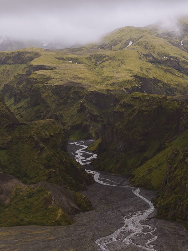
Thórsmörk (Þórsmörk Nature Reserve in Icelandic and named after the Norse god Thor) is a remote area in the Iceland Highlands where three valleys converge under three imposing glaciers, forming a dramatic wilderness of spectacular scenery.
Huge moss-covered mountains dwarfed by even bigger glaciers are divided by a swathe of black gravel carved out by rivers charging along the valleys. Set off into these landscapes on a Thórsmörk hike and you’ll be enjoying one of the best wilderness areas Iceland has to offer.
In under 1 hour, you can hike up to breath-taking panoramas, give yourself half a day and you can see many of the highlights of the region.
Thórsmörk is one of the most challenging places to drive to in the highlands and it is generally not recommended unless you have a large 4×4 and plenty of experience crossing deep rivers. The good news is that there is a comprehensive public transport system and plenty of tours from Reykjavík.
All the details are in our guide to Thórsmörk.
HOW TO GET TO THÓRSMÖRK
Route – F249 to Básar Huts is the only route that does not require a specially modified 4×4 | Difficulty – Very Challenging; 2 large river crossings | Vehicle – Large 4×4 only (with experienced driver) | Time – 1 hour, 10 minutes from Seljalandsfoss
READ MORE
Visiting Thórsmörk – bus information, tours, hikes + map
TOUR


9 – MAELIFELL
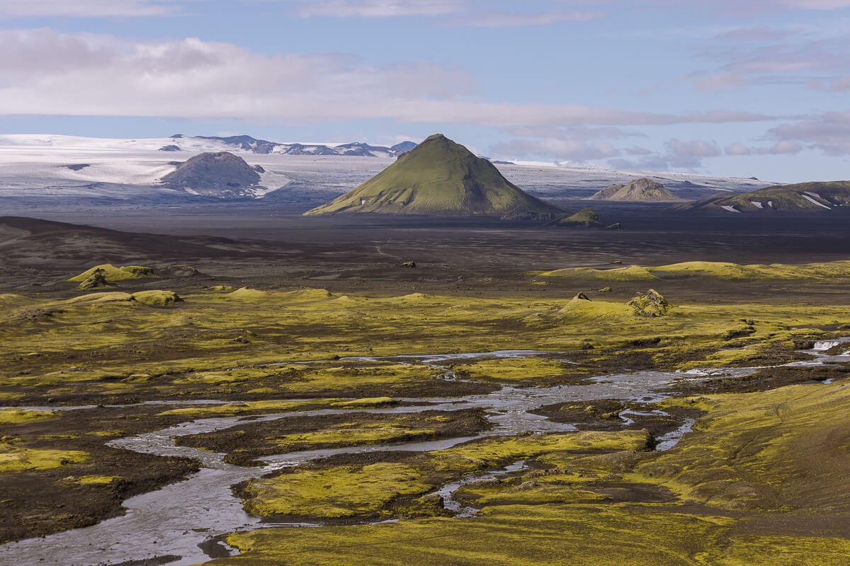
Maelifell is a dramatic cone-shaped mountain surrounded by a massive expanse of black sands in a remote corner of the highlands of Iceland. The 791-metre-high cone of Maelifell was once covered by a glacier, but the mountain was revealed as the ice retreated at the end of the last Ice Age.
This distinctive mountain is now an absorbing sight as it stands alone among the black sands at its base with the huge Mýrdalsjökull glacier in the background.
There are 3 different routes to Maelifell, which we cover in more detail in our Maelifell guide. The easiest is via the F232 from the south. It’s a stunning drive over the black sands of Maelifellsandur and involves a river crossing that requires at least a mid-sized 4×4.


10 – RAUÐIBOTN
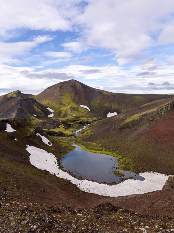
Rauðibotn is a colourful red and green crater which is part of a chain of volcanic craters between Mýrdalsjökull glacier to Vatnajökull glacier. The colourful crater stands in contrast to the wastelands that surround it, and the whole area is made even more spectacular by the rivers and waterfalls that curve through the landscape.
It’s a beautiful and surreal location in the Iceland highlands that’s best seen by following the hiking trail that contours the rim, crosses gushing waterfall and visits emerald-green lakes.
The highlight of Rauðibotn, however, is that it provides a great view of Maelifell.
Getting to Rauðibotn involves travelling on the F210 from Grafarkirkja; a pretty bumpy mountain road with a few small to medium river crossings. It’s achievable for anyone in any sized 4×4.
HOW TO GET TO RAUÐIBOTN
Route – F210 from the east (starting on the F208 near the church in Grafarkirkja) | Difficulty – Medium. Smallish river crossings and a bumpy road | Vehicle – Any size 4×4 | Time – 1 hour, 15 minutes one way.
READ MORE


11 – HOLUHRAUN
Holuhraun is a lava field in a remote part of the highlands just north of the Vatnajökull ice cap.
It’s situated between two massive volcanic systems, Askja and Barðarbunga and was last active in August 2014 when an eruption in a fissure continued until February 2015. It was the largest eruption in Iceland in 230 years and significantly expanded the existing lava field to an area of 85 square kilometres.
Holuhraun is 9 miles (15 kilometres) from Askja and can be reached by continuing on the F910. The road heads through fairly deep sand in places and it feels like desolate barren wilderness.
It takes around 45 minutes to drive to Holuhraun from Drekil Campsite in Askja.
HOW TO GET TO HOLUHRAUN
Route – F910 from Drekil Campsite in Askja | Difficulty – Medium to Challenging | Vehicle – mid-sized 4×4 | Time – 45minutes on top of the 3 hours to Askja
TOURS


12 – ALDEYJARFOSS
Aldeyjarfoss is a dramatic Iceland waterfall right on the northern edge of the F26 Sprengisandsleið Road, the longest mountain road in the Iceland highlands.
The falls are fed by the Skjálfandafljót river which drops 20 metres as a powerful cascade to an icy-coloured pool at the base of the falls. The breath-taking element of Aldeyjarfoss however is the symmetrical basalt columns which form the sheer-sided walls curving around the base of the waterfall.
Driving to Aldeyjarfoss from Route 1 only involves a few minutes on the F-26, the rest is on normal gravel tracks.
Just 5 minutes further south on the F26, Hrafnabjargafoss Waterfall is an amphitheatre of powerful water curving around a central rock. It’s a great addition to Aldeyjarfoss and you’ll probably find very few people make the detour.
HOW TO GET TO ALDEYJARFOSS
Route – 844 from Goðafoss, then F26 | Difficulty – Easy; no river crossings | Vehicle – any 4×4 | Time – 45 minutes


13 – HAFRAHVAMMAGLJÚFUR
Hafrahvammagljúfur is an 8-kilometre canyon located in a remote part of the highlands in East Iceland. It drops 200 metres deep from the barren landscape that surrounds it creating an awe-inspiring scene.
The gorge starts from the Kárahnjúkavirkjun Dam, one of the largest hydroelectric power plants in Iceland. The best viewing point is from a recently constructed viewing platform which is a short walk from the Hafrahvammagljúfur car park.
The car park is down a steep rocky track that leads east from the F910.
The F910 is the challenging road that heads to Askja, but this eastern end is much easier and great fun. It seemingly soars across the roof of Iceland providing great views across to Vatnajökull glacier.
You can access this section of road either from the north (via F907) or from the south. Neither involve any river crossings, but the road is bumpier than a gravel track. It’s a great drive to do if you are staying in the Eastfjords region.
HOW TO GET TO HAFRAHVAMMAGLJÚFUR
Route – 910 & F910 from Brekka or F907 & F910 from Rte 1 north | Difficulty – Easy to Medium; no river crossings | Vehicle – any 4×4 | Time – 1h 15 minutes either route


14 – LAUGAVALLALAUG (LAUGAVELLIR)
Laugavallalaug (sometimes referred to as Laugavellir) is a hot spring in the Laugavalladalur Valley and a beautiful oasis in the middle of nowhere. A naturally heated waterfall drops into a small pool that has been dammed by stones providing an idyllic bathing spot amongst the vast open plains of the Iceland highlands.
The waterfall plunges at a temperature of around 70°C (158°F) but cools to around 40°C (104°F) as it mixes with the cold water in the pool. The perfect temperature to have a relaxing soak as you enjoy the scenery.
It was one of our favourite experiences in Iceland and – in our opinion – the best thermal hot springs in Iceland due to its remote location (we were there alone) and the completely natural environment.
Laugavallalaug is down a scenic track off the west side of the F910. It is just opposite Hafrahvammagljúfur Canyon and the two together make a great day out, especially if you include Stuðlagil Canyon and/or Hengifoss waterfall.
The track is pretty easy but the F910 can be quite bumpy. There is a medium size river crossing just before the hot springs, but there’s a car park and a footbridge if you don’t want to drive across it. The pool is 5 minutes’ walk from the footbridge.
HOW TO GET TO LAUGAVALLALAUG
Route – 910 & F910 from Brekka or F907 & F910 from Rte 1 north | Difficulty – Easy to Medium; no compulsory river crossings | Vehicle – any 4×4 | Time – 1h 15 minutes either route
READ MORE


15 – LANGJÖKULL
Langjökull is the second largest ice cap in Iceland, after Vatnajökull, stretching about 50 kilometres long (from where it gets the name long glacier) and 20 kilometres wide. In some places, the ice is up to 580 metres thick.
The glacier is in a very active geothermal area with two volcanic systems stretching out in opposite directions underneath the massive expansive of ice. One of them is Hveravellir mentioned above. The glacier also feeds Gullfoss and the hot springs at Geysir.
A man-made tunnel has been carved into the ice where you can take a tour to learn more about the unique geology of Langjökull and snowmobile tours are also popular at the glacier.
The journey here is easy and along the 551 and 550 Kaldidalur roads. At the end of the 551 you come face to face with the glacier. From here specially designed buses make their way onto the ice. Don’t attempt to drive onto the glacier.
HOW TO GET TO LANGJÖKULL
Route – 550 Kaldidalur & 551 | Difficulty – Easy; no river crossings | Vehicle – any 4×4 | Time – 45 minutes from Húsafell in the north, 1 hour 15 minutes Thingvellir in the south
TOURS


PLANNING YOUR ICELAND TRIP
Iceland is an excellent destination for semi-adventurous travellers who like to get off the beaten track and immerse themselves in stunning scenery. Here’s some more reading from us to help plan your journey to the land of fire and ice.
If you found this guide useful, we’d love it if you could follow us on Instagram.
GENERAL TRAVEL TIPS
15 useful travel tips for visiting Iceland
How to drive the F-Roads in Iceland
Planning your epic Iceland vacation
All you need to know about driving in Iceland
OTHER GREAT DESTINATIONS
How to visit the Fagradalsfjall Volcano
A guide to visiting the Myvatn area
A BIG THANK YOU
We’ve been providing free travel content on Anywhere We Roam since 2017. If you appreciate what we do, here are some ways you can support us.
Thank you!
Paul & Mark
FOLLOW US ON INSTAGRAM
USE OUR RESOURCES PAGE


