Appenzell, Switzerland: Top Things To Do & Best Hikes (2023) | Anywhere We Roam
Appenzell is a hidden gem in Switzerland. Sinuous rocky ridges and blue-green lakes provide a backdrop for some excellent hiking. Here’s what to see and do in Appenzell.
While tourists flock to Zermatt and the Berner Oberland, Appenzell remains surprisingly quiet.
The mountains may not be as high or the valleys as deep, but the sharp ridges and serrated rock edges make this an excellent hiking destination.
It’s also accessible. Cable cars provide easy access to excellent hikes, breathtaking views, and scenic huts carved into the rock.
If you’re a fan of the dramatic spiky peaks and alpine meadows like those of the Italian Dolomites, then Appenzell might be a great destination for you.
Here’s our complete guide to Appenzell and the areas that surround it including what to see, the best hikes, and where to stay.
UPDATES // We do our best to keep the information in this guide up to date, if you notice anything has changed, please leave a comment below.
BOOKINGS // Booking your trip via the links in this guide will earn us a small commission, at no extra cost to you. Thanks for your support – Paul & Mark.


WHERE IS APPENZELL?
Appenzell is in the northeastern part of Switzerland, 15 kilometres from the Austrian border. It lies at the foot of the Alpstein Mountains in the region of Apenzellerland about 1 hours’ drive from Zurich.
It is famous for its eponymously named ‘Appenzeller cheese’ and for the stunning beauty of its countryside.
WHEN TO VISIT APPENZELL?
June to the end of September is the best time to visit Appenzell.
The summer season in the high Swiss Mountains can be short. Snow often covers the trails on the 4,000m high mountains, and the huts and cable cars can remain closed until July.
However, the mountains in Appenzell are not as high, only reaching 2,500m. This means that the summer season can last much longer.
The main cable cars are open all year and the mountain huts open from May until October.
You might find snow on the higher trails until June or July. Snow can come again in September. However, you can hike many of the lower paths from June to October.
Appenzell is also much less busy than its more famous rivals (Zermatt and the Berner Oberland), so even in peak summer, it doesn’t feel too crowded.


WHAT TO SEE IN APPENZELL
1 – AESCHER HUT & WILDKIRCHLI
Aescher Hut is the iconic image of Appenzell.
Beneath a 100m high cliff, this lovely wooden guesthouse perches on a narrow ledge. It seems to almost hang in the air as the dramatic scenery of the Alpstein mountains stretches below.
The hut was built 160 years ago by farmers. They needed a place to rest while their goats grazed on the hill. Today, the hut offers accommodation, delicious food and drinks, and a fantastic outdoor mountain terrace. It’s one of the best you’ll find anywhere.

The hut is only a 25-minute hike from the top of the Ebenalp Cable Car and the walk can be undertaken by almost anyone.
Along the way you’ll pass through a dark cave (bring a phone with a torch) and a hermitage called Wildkirchli, where Priest Ulmann lived as far back as 1658.
It’s a great spot for lunch but it can get busy, so try to arrive a little early. The hut is open from May to the end of October.
DETAILS | EBENALP CABLE CAR
departs – Wasserauen Cable Car Station | price – 35 CHF return, 22 CHF single. 50% discount with Swiss Half Card | hours – All Year. Roughly 7:30 am to 6:00 pm but check times.


2 – CATCH THE SEEALPSEE REFLECTIONS
Seealpsee is one of the most beautiful lakes in Switzerland. Sitting at 1143m in altitude, it’s blue-green waters are hemmed in by towering mountains on three sides.
There are great views from the Berggasthaus Ebenalp. It’s a short walk from the top of the Ebenalp Cable Car Station. However, the best views in the area are from the Berggasthaus Seealpsee which is at the eastern end of the lake.
The hike from Wasserauen to the eastern end of Seealpsee takes a little over an hour. However, it is worth it for the reflection of the snowy triangular peaks in the water.
The Seealpsee hut offers overnight accommodation, food, and drink, and even has a couple of boats for hire. The waters look very inviting for a swim – but it’s not very warm!
TIP | Set your alarm and head up in the early morning for the best photos and reflections.


3 – SEE THE BEST SHÄFLER RIDGE VIEWS
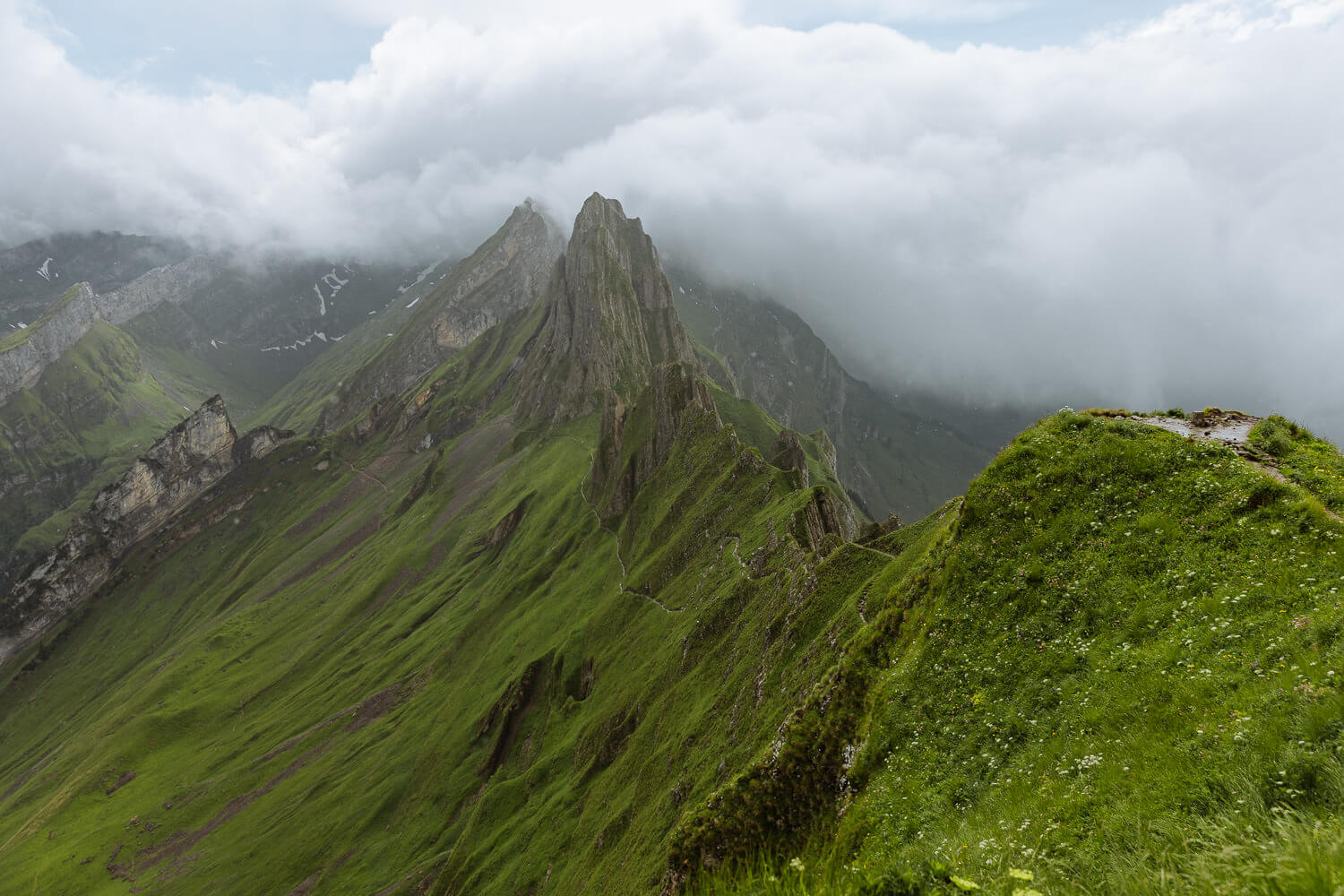
There are two peaks that dominate the Appenzeller region: Säntis at 2,502 metres and Altmann at 2,432 metres. The sinewy spines of ridges that rise and fall below the peaks is one of the defining features of the Appenzell region.
One of the finest is Shäfler Ridge. This series of serrated rocky peaks looks like a saw disappearing into the distance. The best viewpoint of the ridge is from Shafler Hut, a 1-hour walk from the top of the Ebenalp Cable Car Station (see hike 2 below).
The hut sits imperiously on the top of a ridge and has staggering views in all directions. Soak it all in with a beer on the outdoor terrace.


4 – KRONBERG TOBOGGAN RUN & ROPE PARK
At the bottom of the Jakobsbad-Kronberg cable car is the Kronberg bobsleigh track. The plastic sled can be ridden alone or in pairs making it great for both children (above 6 years old) and parents.
The sled is on rails and pulled up 450 metres before it’s released to slide 1,000 metres back down to the valley floor. There’s a brake lever to reduce the speed if things get too fast.
Next to the toboggan run is a fixed-rope park with 25 ziplines spanning a total length of 1,210m. Children aged over 6 and above 110 cm tall, can swing from tree to tree, as they make their way around the platforms.
It’s a fun attraction in Appenzell for families.
5 – SÄNTIS CABLE CAR
At 2502m Säntis is the highest mountain in the Appenzell region. A cable car whisks you to the summit in under 10 minutes.
From the top, the ridges that make Appenzell so special, stretch into the distance in every direction. In total, you can see 6 different countries: France, Germany, Italy, Austria, Liechtenstein, and Switzerland.
Säntis is also known as ‘weather mountain’ and it has been collecting data since 1882. The station now houses an exhibition all about snow, ice crystals, and glaciers.


Finally, there is a series of different activities that run throughout peak summer. They cost a bit more but allow you to be at the summit for dawn (great for photographers), starry nights, or full moons. Check out the Säntis event calendar.
At the top, there’s a big indoor restaurant. But even better is the Alpine Hut. It’s tucked around the back on the southeast side of the summit. It serves traditional food on a terrace with great views.
TIP | If you’re an adventurous hiker and don’t mind heights then try the Lisengrat trail. It’s a wonderful walk across the rocky summits of this wild and desolate landscape. See hike number 6 below.
DETAILS | SÄNTIS CABLE CAR
departs – Schwägalp Cable Car Station | price – 58 CHF return. 50% discount with Swiss Half Card | hours – 7:30 am to 6:00 pm Mon-Fri, to 6.30 pm Sat & Sun | website – saentisbahn.ch


6 – APPENZELL OLD TOWN
The picturesque old town of Appenzell is well worth exploring.
Above the quiet streets, there are colourful chalets painted in bright pastel colours. The highlight is Landsgemeinde Square, but don’t miss the famous Appenzell cheese shop.
The Museum Appenzell has a collection of cultural and historical items. These include embroidery, traditional costumes, folk-art paintings, and painted furniture.
The Art Gallery Appenzell shows art from different periods. It’s all displayed in a clean, white space. It’s worth seeing for the structure itself with its overlapping metal squares shaped like a saw.
There’s also an indoor pool and tennis court for some exercise on those rainy days.
SWISS SAVINGS
SWISS TRAVEL PASS
The Swiss Travel Pass provides unlimited access on trains, buses, and boats throughout Switzerland including panoramic trains.
The Swiss Museum Pass is also included which provides free access to over 500 museums including the Matterhorn Museum, the Glacier Garden in Lucerne, the Castle of Gruyères, and St Gallen’s library.
SWISS HALF CARD
Purchase train, bus, boat, mountain railways and cable cars at half price with the Swiss Half Card. This is a great opinion if you are driving yourself but intend on using cable cars.
7 – HOHER KASTEN REVOLVING RESTAURANT
Ascending from Brülisau village, the Hoher Kasten cable car is a breath-taking ride. It soars over lush meadows and picturesque landscapes.
As the gondola rises, it reveals an Alpine panorama. Snow-capped peaks, verdant valleys, and blue-green lakes come into view.
The journey culminates at the summit station of Hoher Kasten, offering 360-degree views of the Alpstein mountains. From here you can also see the Austrian Alps.
At the top, explore hiking trails and savour the views.
For a lunch to remember, try the revolving restaurant. It rotates over the course of an hour providing a changing view. The breakfast buffet is served until 10.30 am and the afternoon snack platter starts at 2.30 pm.
DETAILS | HOHER KASTEN CABLE CAR
departs – Brülisau Cable Car Station | price – 46 CHF return, 28 CHF single. 50% discount with Swiss Half Card | hours – 8:00 am to 5:30 pm but check latest times.


8 – SAXER LÜCKE & FÄLENSEE
Two of the most stunning sights in the Alpstein Mountains are quite close to one another.
The Saxer Lücke Viewpoint looks out at some of the most remarkable shaped mountains you’ll find anywhere. Reminiscent of Seceda in the Italian Dolomites, the jagged peaks form a thin wall of rock.
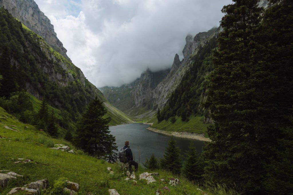
Fälensee Lake lies at the bottom of these remarkable shapes. Its waters are surrounded by sheer walls of rock, culminating at jagged peaks. Backed by the 2,435m Altmann mountain, it’s a breathtaking scene.


To see both, take the cable car from Frümsen to Staubern Hut. Then hike for about 1 hour 15 minutes to Saxer Lücke viewpoint. Along the way there are fantastic views down to Fälensee.
If you enjoy hiking, you can take a great circular walk starting at the top of the Hoher Kasten cable car. This walk offers stunning views before returning to Brülisau. See hike 5 below.
DETAILS | FRÜMSEN STAUBERN CABLE CAR
departs – Frümsen Cable Car Station | price – 36 CHF return, 18 CHF single. 50% discount with Swiss Half Card | hours – 9 am to 10 pm (Apr, Nov to Dec) / 8 am to 10 pm (May & Oct) / 7 am to 10 pm (Jun to Sep) | website – Appenzell-ch

9 – ST GALLEN ABBEY LIBRARY
The town of St Gallen is 30 minutes from Appenzell.
Its medieval streets, dominated by St Gallen Cathedral, conceal a magnificent abbey complex and a UNESCO World Heritage Site. Napoleon dissolved the abbey in 1805, which had maintained a monastic presence for almost 1,000 years.
The books it held survived and are now housed in a remarkable baroque and rococo library. It was built between 1758 and 1767 and it’s a magnificent place to visit in the Appenzell area.


Wood panelled bookcases and ornate ceilings adorn the library. Glass display cabinets contain books dating back to the ninth century. Don’t miss the tablets and bibles in the vault downstairs.
The two ivory tablets in the centre are thought to date back to the late 8th century. Some say they may have been presented to Charlemagne.
Don’t miss the interior of the Baroque cathedral. The whole complex is an excellent rainy-day activity in Appenzell.
DETAILS | ABBEY LIBRARY OF ST GALLEN
hours – 10 am to 5 pm (Monday to Sunday) | cost – CHF 18 Adults / CHF 12 Students / + CHF 5 Audio guide | Free entry for Swiss Travel Pass holders | website – stiftsbezirk.ch


BEST HIKES IN APPENZELL
Appenzell is an amazing hiking destination with walks for all levels of fitness and experience.
There are simple walks to beautiful views. Others are harder with narrow ridges and sharper inclines. Here are our favourites hikes in Appenzell including maps to help you navigate.
HIKE 1 / AESCHER HUT HIKE
Distance – 1.4 kilometres | Time – 50 minutes | Elevation – 120m ascent and descent | Difficulty – Easy | Map – Marked in orange on the map below.
This is a great there and back walk that can be completed by almost anyone. It ends at Aescher Hut, the iconic image of Appenzell.
The trail begins at the top of the Ebenalp Cable Car and slowly descends following signs for Aescher Hut. It passes through a dark cave (useful to have a torch on your phone) before exiting at the Wildkirchli, a hermitage cut into the rock.
The path then crosses a wooden bridge. Around 25 minutes after leaving Ebenalp, you’ll arrive at Aescher Hut.
The easiest way back is to return the way you came (50 minutes round trip). But more adventurous hikers could complete a loop (1 hour 30 minutes) returning via a series of steep switchbacks.


HIKE 2 / SEEALPSEE HIKE
Distance – 5.6-kilometre loop | Time – 2 hours | Elevation – 270m ascent and descent | Difficulty – Easy to Medium | Map – Marked in blue on the map below (go clockwise)
This pretty hike is all about the views of Seealpsee. From its eastern end, the reflections of the Alpstein mountains in the blue green waters are a real crowd pleaser.
The trail starts at Wasserauen and heads up through the trees. The path cuts through meadows and passes a local farm selling cheese. From here, views of Seealpsee appear in front of you.
It takes just over an hour to reach the lake, where the Seealpsee hut offers refreshments.
It can be undertaken by anyone with a reasonable amount of fitness.
Come in the early morning for the best light and photo conditions.
You can complete a loop by heading back on the wide track that runs alongside the Schwendibach River.


HIKE 3 / SHÄFLER HUT VIEWPOINT HIKE
Distance – 6.5-kilometre loop | Time – 2 hours 30 minutes | Elevation – 450m ascent and descent | Difficulty – Easy to Medium | Map – Marked in red on the map below.
The Shäfler Ridge is one of the most dramatic sections of the Alpstein Mountains. This hike takes you to a viewpoint that overlooks it.
It begins at the Ebenalp Cable Car Station and heads down to Aescher Hut. From here, the trail narrows and climbs under a wall of rock.
At a junction of paths make a quick right, then left, and continue with the wall of rock on your right.


The path slowly edges its way under the rock before appearing on top of the ridge at Chlus.
Turn left and follow the trail to Shäfler Hut (this section can be muddy after rain).
From the hut the views over the ridge are excellent.
Complete a loop by returning to Chlus and then sticking to the ridge top as it returns to Ebenalp.
The hike can be completed by anyone with a bit of hiking experience and reasonable fitness. There is a drop-off on your left-hand side as the path heads under the wall of rock. However, it doesn’t feel particularly exposed or precarious.


HIKE 4 / SHAFLER RIDGE HIKE
Distance – 12 kilometres | Time – 5 hours | Elevation – 630m ascent and 1,350m descent | Difficulty – Medium to Challenging and not for those with a fear of heights | Map – Marked in purple on the map below.
This magnificent hike is a fantastic exploration of all that is great about the Appenzell region. Experience the spiky ridges, the best lakes, exposed trails, and stunningly situated huts.
It begins at the Ebenalp Cable Car Station, follows the top of the ridge to Chlus. From here, the hike continues up to the Shäfler Hut. (Alternatively, you could take the even better, but longer, route via Aescher Hut)


From Shäfler Hut it gets a bit tricky. Heading along the narrow ridge, the path makes a descent with near-vertical drops on one side. Handrails are provided in places. You should not attempt it after rain and it’s not good for anyone with a fear of heights.
After about half an hour the exposed section comes to an end. The trail makes a lovely traverse under the spiky ridge before bearing left and descending to Mesmer Hut. Take a break and recharge before the next descent down a series of zigzags to Seealpsee.
Finally, progress on to Wasserauen.
The entire hike is about 5 hours of walking time, but you’ll want longer to take breaks and soak in those views. There are plenty of great huts at regular intervals along the way.


HIKE 5 / SAXER LÜCKE PANORAMA TRAIL
Distance – 17 kilometres | Time – 6 hours | Elevation – 450m ascent and 1,275m descent | Difficulty – Medium to Challenging | Map – Marked in grey on the map below (go clockwise).
For the first three to four hours this hike has wondrous views taking in the Saxer Lücke viewpoint and Fälensee Lake.
It begins at the top of the Hoher Kasten Cable Car Station and descends via zigzags to a saddle on the ridge. Turn left following signs to Staubern. From here the trail rises and falls, sometimes staying below the ridge and sometimes on top.
After about 2 hours you reach Staubern Hut, from where you should follow signs to Saxer Lücke (1 hour, 20 minutes).


The trail heads under a wall of rock before rising again to the top of the ridge. Magnificent views of Saxer Lücke and Fälensee stretch out before you.
The path now zigzags steeply to Bollenwees Hut on the edge of Fälensee. Take in the views and have a well-deserved break before following the long path back to Brülisau. We should point out that the path gets a little boring towards the end.
There is nothing technically difficult on this hike and there are no nasty exposed paths. But it’s a long day in the mountains and requires a good level of fitness.


HIKE 6 / LISENGRAT HIKE
Distance – 2.1 kilometres each way | Time – 1 hour 30 minutes each way | Elevation – 400m ascent and descent | Difficulty – Medium but not for those with a fear of heights | Map – Marked in green on the map below.
This hike traverses the first half of the ridge between the two highest peaks in Appenzellerland – Säntis (2,502m) and Altmann (2,432m).
While it’s not that long, the path is exposed in several places. There are steep drop-offs, sometimes on both sides. To make things even trickier there can be snow on the trail well into July. However, regular handrails make it much safer than it would otherwise be.


The path leaves from beside Säntis Alpine Hut, at the top of the Säntis Cable Car Station. Follow the signs for Rotsteinpass. There’s a hut at Rotsteinpass which should take between 75 and 90 minutes to reach. The views all along the route are sensational.
From the hut at Rotsteinpass, the trail continues up to the summit of Altmann. However, it gets much scarier and more difficult, so unless you are an intrepid alpinist it’s better to return the way you came.
The walk is not long or particularly tiring, but you must have a good head for heights. You should only attempt this hike in good weather.


MAP | HIKES & ATTRACTIONS IN APPENZELL
Appenzell is a region in northeastern Switzerland known primarily for its picturesque landscapes, traditional customs, and cheese production. This map contains all the top attractions in the area, plus our top 5 hikes.
How to use this map / Click on the top left of the map to display the list of locations, then click on the locations to display further information. Click on the top right corner of the map to open a larger version in a new tab or the star to save to your Google Maps.
WHERE TO STAY IN APPENZELL
The town of Appenzell has excellent public transport links to the surrounding sights. Trains run from the town centre to Jakobsbad for the toboggan run and to Wasserauen where you can hike to Seealpsee or get the cable car to Ebenalp.
Buses run to Brülisau (connecting in Weissbad) for easy access to the Hoher Kasten cable car.
Here are our tips for where to stay in Appenzell.
BED & BREAKFAST
HOTEL B&B STOSSPLATZ
This Hotel & B&B is very close to the train station in Appenzell, making it a convenient option. The town centre is a 5-minute walk and breakfast is great.
OUR PICK
COUNTRY RETREAT
HOTEL FROHE AUSSICHT
This quiet retreat In Weissbad, a few miles from Appenzell has wonderful views over Appenzellerland. The restaurant is high quality, and most rooms have an outdoor balcony with sun loungers. The Schwende train station is a five-minute walk and it’s a short drive to the Ebenalp and Hoher Kasten Cable Car Stations. Parking is free.
GRAND OLD TOWN HOTEL
HOTEL APPENZELL
Situated on Appenzell’s historic Landsgemeinde Square, this café-hotel looks the part. The traditional Swiss hotel is painted in bright yellow with colourful pictures on the façade. It’s a short walk to the train and bus stations.

APPENZELL HOLIDAY CARD
Switzerland is not a cheap place to travel, but Appenzell represents great value in an expensive country.
In 2023, if you stay three consecutive nights or more in the same accommodation, you receive a FREE Appenzell Holiday Card. Each visitor gets a card, its valid for 7 days, and includes the following and more.
- Free travel on buses and trains in the Appenzell region.
- 2 Free trips (or one return) on Wasserauen-Ebenalp cable car.
- 2 Free trips (or one return) on Brülisau-Hoher Kasten cable car.
- 2 Free trips (or one return) on Jakobsbad-Kronberg cable car.
- Free entry to the summer toboggan ride.
- Free entry to 5 local museums.
It makes for a great saving and hopefully, it will reappear in 2024. Check with your accommodation before booking.
HOW TO GET TO APPENZELL
By Car – Appenzell is a 1-hour drive from Zurich International Airport, 1 hour 45 minutes from Lucerne, and 2 hours 15 minutes from Saint Moritz.
By Public Transport – Appenzell is 1 hour 40 minutes by train from Zurich International Airport (changing at St Gallen) and 2 hours 50 minutes by train from both Lucerne & Berne (changing at Zurich and St Gallen).


THANKS FOR VISITING // WHERE NEXT?
A BIG THANK YOU
We’ve been providing free travel content on Anywhere We Roam since 2017. If you appreciate what we do, here are some ways you can support us.
Thank you!
Paul & Mark
FOLLOW US ON INSTAGRAM
USE OUR RESOURCES PAGE

